|
Construction & History
of Rock Island Lighthouse Station
In 1847, Chesterfield & Mary Ann Persons
and Azariah & Mary Walton,
joint owners of several of the Thousand Islands in the St. Lawrence
River, sold Rock Island, Sunken Rock Island (a.k.a. Bush Island), and
Gull Island (a.k.a. Crossover Island) to the United States for $250 for
the purpose of erecting lighthouses.
The first lighthouse was
erected on Rock Island in 1847 and was described in 1895 in Haddock's The
Picturesque St. Lawrence River: "Rock
Island, 7 miles further up [from Sunken Rock]; keeper's dwelling of
brick, white, with a low tower on top; dome black; height, 39 feet;
built in 1847; refitted in 1855." The only image of the first
lighthouse known to exist was published in Benson Lossing's 1868 work
entitled "A Pictorial Field-book of the War of 1812":
 |
|
The first lighthouse on Rock Island, as sketched by
Benson J. Lossing in 1858.
|
The earliest publication to
mention Rock Island Lighthouse was Franklin B. Hough's landmark work A
History of Jefferson County in the State of New York, printed in
1854, which said: "Rock Island Light, opposite
the mouth of Mullet Creek, was erected as one of the three beacons
authorized in the St. Lawrence, by the act of March 3, 1853; the other
two being Sunken Rock, near Alexandria Bay, and Cross-over Island, in
Hammond." Since a beacon existed at Rock Island as early as
1847, the "authorization" of 1853 Hough mentions probably refers to
approval for refitting the towers, which eventually happened in 1855.
On 15 May 1848, Chesterfield Parsons,
former owner of the island, was appointed as the first keeper of the
new Rock Island Station. 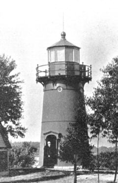
 In 1882, the combination keeper's dwelling and tower were replaced by
separate structures. A conical iron tower was erected on a bedrock
platform at the center of the island, having the foot of its base
approximately 15 feet above mean river level. Similar
towers were erected on Sunken Rock Island and Crossover Island, such that today both stand as examples of what Rock
Island Light looked like during this period.
A few yards away, a one-and-a-half story Victorian shingle-style dwelling was constructed, facing
north, and surrounded by a concrete seawall for protection. A blueprint made circa
1885 depicts the new structures and their relative positions. The photograph
at right, published by Haddock in 1895 shows what
the new tower looked like. (According to an
anonymous diary at Hawn Memorial Library, Clayton, New York, the man
standing in the doorway is M. J. Diepolder,
who was keeper from 1886 to 1901).
In 1882, the combination keeper's dwelling and tower were replaced by
separate structures. A conical iron tower was erected on a bedrock
platform at the center of the island, having the foot of its base
approximately 15 feet above mean river level. Similar
towers were erected on Sunken Rock Island and Crossover Island, such that today both stand as examples of what Rock
Island Light looked like during this period.
A few yards away, a one-and-a-half story Victorian shingle-style dwelling was constructed, facing
north, and surrounded by a concrete seawall for protection. A blueprint made circa
1885 depicts the new structures and their relative positions. The photograph
at right, published by Haddock in 1895 shows what
the new tower looked like. (According to an
anonymous diary at Hawn Memorial Library, Clayton, New York, the man
standing in the doorway is M. J. Diepolder,
who was keeper from 1886 to 1901).
After the tower was erected at the center
of the island the rate of shipwrecks in the vicinity increased, since
the house, trees, and other lights from the mainland obscured pilots'
perceptions of the beacon. On the night of 15 August 1889,
the three-masted schooner A. E. Vickery
struck a shoal near the station and sank, resulting in no
loss of life, but causing great financial loss to its owners. The crew
were rescued and attended to at Rock Island Station.
In the fall of 1894, work was
performed to raise the light tower approximately five feet from its
position in the center of the island, so it could be seen over the roof
of the dwelling. It was set atop a solid octagonal wall of red granite
laid in Portland cement mortar beneath.
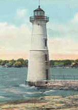
It was
finally thought best to move the light tower to an unobstructed
location. At the turn of the century,
construction began on a walkway, consisting of masonry rubble coated
with concrete, that extended from the north face of the island into the
river. At its end was added a partially submerged platform upon which a
15 foot wide conical brick base was built. In 1903, the old iron tower
was then taken up from its place at the center of the island and placed
atop the brick base, thus maintaining more or less the height of the
previous light above water level. It is this "stacked" tower that
exists today, such that visitors see the 1882 doorway situated on the
second story of the tower, as shown in the postcard image at upper left.
The light once held a sixth-order fresnel lens, but following World War
II, the station was deactivated and the old lens removed. At one
time the lamps were powered by a gasoline generator. In 1988, the
station was converted to use solar power. Today, the tower emits a
white light, but is no longer officially used as a navigational aid.
Several other buildings were added to the station through the years,
most of which survive today, making the station unique in the
region: a carpenter's shop (1882), generator house (1900), and
boathouse (1920). The
fieldstone smokehouse (1847), now identified as the painthouse, may
have originally been the oil house, and is the only structure to have
survived from the earliest period.
In late summer 1976, the Federal Bureau of Outdoor Recreation in
Washington, D.C., announced a transfer of "surplus property"—the Rock
Island Light Station—to the Thousand Islands Park Commission. The property
was then valued at $50,000 and was described as "a 50-foot-high light
tower, frame lightkeeper's dwelling, workshop, boathouse, paint locker,
generator house and concrete seawall."
On 14 November 1978, the Rock Island Light Station was listed on the
National Register of Historic Places (reference #78001855), providing
recognition and protection of the site. During the summer leading
up to the announcement, the Thousand Islands State Park and Recreation
Commission began a rehabilitation program at the site which included
painting and installing a new roof on the lighthouse, cleaning iron
work and removing dead trees and brush from around the island.
From 2010 to 2013, extensive repairs and renovations were made to all
of the buildings and grounds. On 4 June 2013, the grand geopening
of the station as Rock Island Lighthouse State Park took place under
the auspices of New York State Office of Parks, Recreation &
Historic Preservation, which owns and manages the site. The
island and its buildings are open to the public for touring.
|
References
Benson, Lossing. The Pictorial Field-Book of the War of
1812. New York: Harper, 1868. Image of Rock Island ca. 1855 adapted
from scan created by Bill Carr at wcarr1@nycap.rr.com,
available at http://freepages.history.rootsweb.com/~wcarr1/Lossing2/Chap29.html#e069a.
Visited on 12 December 2001.
Clifford, J. Candace and Mary Louise Clifford.
Nineteenth-Century Lights: Historic Images of American Lighthouses.
Alexandria, Va.: Cypress Communications, 2000.
Haddock, Jonathan. The Picturesque St. Lawrence
River. a.k.a. A Souvenir of the Thousand Islands of the St.
Lawrence River. Alexandria Bay, NY: Thousand Islands Club, 1895.
Hough, Franklin B., A History of Jefferson County in the State of
New York, From the Earliest Period to the Present Time. Watertown,
NY: Sterling & Riddell, 1854. p 214.
Tinney, James and Mary Burdette-Watkins. Lighthouses
of the Seaway Trail. Sackets Harbor, NY: Seaway Trail
Foundations, Inc.
Rock Island Lighthouse Site File. Records of the U.S. Coast Guard
Lighthouse Service. Lighthouse Service Site Files, 1790-1939. National
Archives, Washington, D.C., Rec. Grp. 26 E66, Stack 11 E 4, Row 13,
Compartment 76, Shelf 2, Box 138, Folder NY 101.
Correspondence dated 28 November 1978 from Larry E. Gobrecht, National
Register and Survey Coordinator to Mrs. Bessie E. Walldorff, Orleans
Town Historian. Orleans Town Historian's Office, Sunrise Ave.,
LaFargeville, New York.
Correspondence dated 7 February 2001 fromTracy DuFlo,
Producer at WPBS-TV for "Lighthouses of the Seaway Trail" video (2000).
Correspondence dated 20 February 2001 from Thomas Mitchell,
Thousand Islands Region Office of Parks, Recreation, and Historic
Preservation.
"Park Commission Given Lighthouse." Watertown Daily Times, 1
September 1976.
"Rock Island Lighthouse Now in National Register." Watertown
Daily Times, November 1978.
|
© 2000-2013,
Rock
Island Lighthouse Historical & Memorial Association
Online at: http://rockislandlighthouse.org/construction.html
|